When the glacial floods at Sikkim unfolded in late 2023, it was more of a shock than a surprise. A research paper published about four years earlier accurately predicted the events with precise details.
GLOFs or Glacial Lake Outburst Floods, are ticking bombs sitting in the lap of Himalayas with the potential to sweep away the growing population in the mountains. There are as many as 7,500 of them, and Sikkim only is home to 10 percent of the total, with about 25 assessed as high-risk. Glacial lake inventory of Uttarakhand lists 1266 glacial lakes as witnessed using satellite data. But the real problem is 13 most vulnerable glacial lake catagorised as risk level A by National Disaster Management Authority (NDMA) in Uttarakhand. There lakes are prone to GLOFs, the kind of events that resulted in several disasters in the Himalayan states in the recent years.
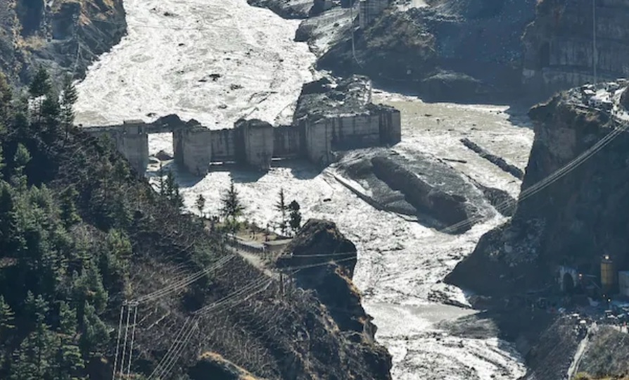
India Today spoke to one of the scientists behind the paper who had warned about the risk of calamity in Sikkim – Ashim Sattar, a glaciologist at the Indian Institute of Science in Bengaluru. He and two colleagues had described in their paper a potential nightmare in which a flood wave would emanate from South Lhonak Lake and inundate the town of Chungthang, causing “substantial damage to the hydropower dam site” there.
In the actual event, the dam was swept away entirely, and the home ministry estimates that 80 percent of Chungthang was affected.
On the roof of the world, the people living among Sikkim’s glorious heights are exposed to an even greater degree of risk than most Indians, on the plains below. At such high altitudes and steep inclines, the valleys have long defined the Himalayas’ only inhabitable landscapes. But their perch is precarious; climate change is aggravating the dangers posed by glacial lakes in Sikkim, Uttarakhand and around the world.
The NDMA which operates under the Union Ministry of Home Affairs has identified 188 lakes in the Himalayan states that can potentially be breached because of heavy rainfall. Thirteen of the most vulnerable lakes lie in Uttarakhand.
The primary cause behind global warming and the rising surface temperature has increased the risk of GLOFs. An even warmer average temperatures changing our mountains, glaciers are melting faster, reducing the amount of water locked up in ice. “The glacial lakes are growing in an exponential manner and pushing up against their natural capacity,” Dr. Ashim Sattar told India Today.
The escalation of such incidents has been partly fueled by rapid infrastructure development in fragile zones. Particularly noteworthy is the surge in Glacier Lake Outburst Floods (GLOFs) in the Himalayan region since 1980, especially along the southeastern Tibetan and the China-Nepal border areas. This trend was highlighted in a study titled ‘Enhanced Communities and Infrastructure in the Third Pole’, which was published in the journal Nature in 2023.
“Approximately 6,353 sq km of land could be at risk from potential GLOFS, pos- ing threats to 55,808 buildings, 105 hydropower projects, 194 sq km of farmland, 5,005 km of roads, and 4,038 bridges in the region,” according to the study.
There is the effect of global warming on the permafrost beneath the Himalayan ice cap, which is home to most of the world’s ice outside the North and South Poles. Climate change, Sattar mentions, “is playing a role in permafrost degradation.” As it weakens, soil and snow lose their grip on each other. Avalanches follow, sometimes causing floods even without a GLOF, such as those that inundated the state of Uttarakhand in 2021.
In the Himalayan cryosphere, it is evident in the terms of glacier shrinkages and varied river runoff which has put about 3 million people in India and 2 million in Pakistan at the risk of GLOFs.
In recent years, Uttarakhand has been plagued by two significant Glacial Lake Outburst Flood (GLOF) events, leaving devastating impacts on its terrain and inhabitants. The first calamity, occurring in June 2013, wrought widespread destruction across the state, with the Kedarnath valley bearing the brunt of the catastrophe, resulting in a loss of thousands of lives. Subsequently, in February 2021, Chamoli district faced the onslaught of flash floods triggered by the abrupt rupture of a glacier lake, further compounding the region’s woes
Uttarakhand’s vulnerability to GLOF incidents is underscored by the presence of 13 glacial lakes identified as potential hotspots for such disasters. These lakes have been categorized into three risk levels, denoted as ‘A’, ‘B’, and ‘C’. Of particular concern are five lakes classified under the ‘A’ category, including Vasudhara Tal in the Dhauliganga basin of Chamoli district, and four others situated in Pithoragarh district – Maban Lake in Lassar Yangti Valley, Pyungru Lake in the Darma basin, and two unclassified lakes in the Darma and Kuthi Yangti valleys. Spanning areas ranging from 0.02 to 0.50 square kilometers, these lakes are perched at elevations varying from 4,351 meters to 4,868 meters above sea level.
The growth of a supraglacial lake, Vasundhara Tal, formed in the Raikana valley of Kumaun Himalaya, Uttarakhand identified through satellite data and assessment of its discharge potential.
Vasundhra Tal
Vasundhara Tal – the supraglacial lake situated at an elevation of 4795 m at the left edge of the snout of Raikana glacier from which Raikana Nadi (river) originates. The melt water in Vasundhara Tal forms source of the drainage for Raikana river, in the NE part of Chamoli district, Uttarakhand. The magnitude of a flood caused by breach of the moraine dam is relevant for further hazard analyses.
Compounding this precarious situation is the prospect of rising surface temperatures, forecasted to escalate the existing risks in Uttarakhand. A study conducted in 2021 by the Potsdam Institute for Climate Research (PIK) in Germany and The Energy and Resources Institute (TERI) in New Delhi, titled ‘Locked Houses, Fallow Lands: Climate Change and Migration in Uttarakhand, India’, projects a concerning increase in the hill annual average maximum temperature by 1.6-1.9 degrees Celsius between 2021 and 2050. Such climatic shifts portend a heightened likelihood of GLOF occurrences within the state, exacerbating its vulnerability to environmental hazards.
Ashim Sattar highlights that the way forward is a “detailed GLOF risk assessment to be undertaken by the government with continuous monitoring of the glacial lakes and it’s surroundings.”


