




Himalaya Harbinger, Rudrapur Burea
Satellite collars have transformed wildlife monitoring, allowing forest officials to track animals across vast and often inaccessible landscapes. Contrary to popular belief, however, they do not provide continuous, real-time tracking. Monitoring teams typically depend on periodic location updates and ground searches to find the animals. If a signal fails to transmit, officials may have to wait several hours for the next update, and during that time there is no way to know where the animal is.
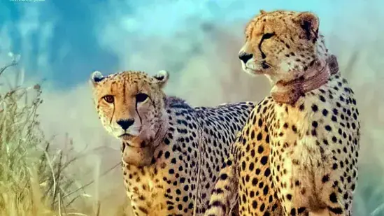
At Kuno National Park in Madhya Pradesh, where officials track around 15 cheetahs, the satellite collars are programmed to transmit a location signal once every six hours. A single missed update can therefore leave teams without a fresh location for 12 hours, and in some cases up to 18 hours.
A recent instance involving a tigress in West Bengal has brought these limitations into focus. On October 29, the radio-collar signal of tigress T-138 at Bengal’s Buxa Tiger Reserve was temporarily lost after she crossed into neighbouring Assam. She had been translocated from Bihar’s Valmiki Tiger Reserve on October 2. Contact was restored only after more than 32 hours.
Kuno field director Uttam Sharma explained how wildlife tracking works, saying that a temporary loss of signal is not unusual and is an inherent part of monitoring. Satellite collars, he added, are not designed to provide a continuous live feed of an animal’s movements. Transmitting that frequently would drain the collar’s battery quickly and make tracking far more cumbersome.
According to Sharma, it is wrong to assume that a collared animal could be watched non-stop, much like a live cricket match on TV. “This is far from reality,” he said, adding that satellite collars are programmed to transmit location signals at predetermined intervals, depending on the monitoring requirements and technical specifications of the device.
“These intervals can range from as short as 10 minutes to several hours, sometimes extending up to 12 hours. There is a direct trade-off between the frequency of location updates and battery life. More frequent transmissions consume more power. A 10-minute transmission interval can exhaust a battery within a day in some operating configurations, while a 12-hour interval may allow it to function for nearly two years,” he said. “For routine wildlife tracking, a transmission interval of three to six hours is commonly considered, depending on the monitoring requirements.”
At Kuno, officials generally set satellite-collared cheetahs to transmit a location every six hours, an interval chosen to balance the need for regular updates with battery life. The collars are expensive, generally costing around ₹4-5 lakh each, making the frequency of transmission an important management decision. Replacing them is also no routine task either.
This also means that if a scheduled location update is missed, the gap between two successful locations can extend to 12 hours, Sharma said. “If the next scheduled transmission is also missed, officials could go 18 hours or longer without a fresh location,” he said.
On October 25, male cheetah KNG-22 was found injured in a forest under the Sheopur forest division near the Kuno park, with pellets from a firearm found in its body during surgery. The cheetah subsequently died. Two men were arrested on October 31 for allegedly shooting the animal, and the weapon used in the killing was recovered.
Sharma said several factors can affect the acquisition or transmission of location data. This includes dense forest canopy that can interfere with a collar’s ability to obtain an accurate GPS location.
“Temporary signal interference or poor satellite geometry can also affect location acquisition. An animal resting under dense vegetation or near water may be in a location where satellite reception is poor,” he said, adding a collar may, therefore, fail to obtain or transmit a location at its scheduled time.
In such cases, monitoring teams have to wait for the next successful transmission, he added. “Despite being fitted with a radio collar, T-138’s signal was unavailable for more than 32 hours after she moved into Assam,” he said, referring to the Bengal case.
At Kuno, satellite tracking is only one component of the monitoring system. Field teams also use very high frequency (VHF) radio receivers to locate and follow animals on the ground.
Cheetahs, however, are highly mobile. Sharma said they move at an average of six to eight kilometres a day and, on several occasions, cover 12-15 km or more. Their movements are often concentrated during early morning and late evening hours.
“This creates a challenge for the ground teams. When a cheetah moves beyond the VHF radio-tracking range, officials have to wait for the next satellite location before attempting to follow it. By the time a team reaches the last reported coordinates, the animal may already have moved several kilometres away, putting it outside the team’s radio range again,” he said. If the next scheduled transmission is also missed, officials have little option but to wait for the next successful location fix.
He also flagged practical limitations to reaching these locations – vehicles cannot travel through forests in straight lines and the actual distance covered by a monitoring vehicle can be several times the straight-line distance between the two concerned locations. “Consequently, maintaining visual or radio contact with an animal throughout the day is an extremely demanding exercise,” he said.
Asked what exactly went wrong while tracking KNG-22, Sharma said the matter is still under investigation. “A detailed report is being prepared on this,” he said.
How animals were tracked before satellite technology
Sharma said wildlife tracking was far more difficult before satellite collars came into use.
When tigers were reintroduced at the Sariska Tiger Reserve in Rajasthan in 2008 and Panna Tiger Reserve in Madhya Pradesh in 2009, their monitoring relied primarily on conventional VHF radio collars.
Teams frequently lost radio signals and had to undertake extensive ground searches to relocate animals, often covering large areas and spending long hours in difficult terrain. Satellite technology has since reduced this burden. Instead of relying entirely on ground-based searches, monitoring teams can use satellite-generated locations to narrow down the search area and then use VHF equipment to locate the animal more precisely,” he said.
Even so, while technology narrows down the search area, finding the animal still demands field teams, coordination and considerable physical effort, making it an arduous exercise.
